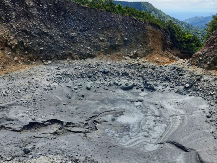
Reports indicate that water levels at Boiling Lake, Dominica, have changed significantly in recent days, a phenomenon that has occurred several times since 1876. The most recent period of instability was observed in December 2023 and in the following months, guides and Forestry officials have reported changes in the lake levels with the latest occurring during March.
According to reports, on March 29th, the lake was observed to experience “a significant drop in water levels once again, when there was little to no water observed in the lake.” Officials state that the observed changes in water levels and activity at the Boiling Lake are “not necessarily related to increased volcanic activity in the area”. However, during these episodes, “harmful gases such as carbon dioxide, can be released and small steam explosions may also occur.”
This most recent cessation of geothermal activity at the lake may be indicative of blockages of underlying vents, which feed into the lake, and is of concern as clearing of this blockage can occur without warning. The UWI-SRC and the ODM – Office of Disaster Management, Dominica say that they continue to monitor the situation and will provide updates accordingly.
The UWI-SRC and the ODM – Office of Disaster Management, are the official sources of information on volcanic activity in Dominica.
The Boiling Lake is a flooded fumarole located in Morne Trois Pitons National Park, a World Heritage Site on the island of Dominica. The lake, located 6.5 miles (10.5 km) east of Dominica’s capital Roseau, is filled with bubbling greyish-blue water that is usually enveloped in a cloud of vapour. The Boiling Lake is approximately 200 to 250 feet (60 to 75 m) across and is the second-largest hot lake in the world after Frying Pan Lake, located in Waimangu Valley near Rotorua, New Zealand.
The lake rests at the bottom of a large sinkhole-like basin. More accurately, it is a flooded fumarole, generally located within the vicinity of a volcano, which emits steam and gases escaping from molten magma below. Currently, the lake is viewable from a broad, cliff-top ledge about 100 feet (30 m) directly above its shore. High rock walls surround and create the basin.
The lake’s grayish-blue water is easily viewed in its perpetual rolling-boil state which looks like a giant pot of water cooking and steaming on a stove. The basin’s water is replenished by rainfall and two small streams which drain into the area.
The water then seeps down to the magma and is heated to the boiling point. The trail leads through another volcanic area called the Valley of Desolation. The air around the area is hot, steamy, and moist, supported by the sharp, acrid smell of sulphur. The area is known to have been filled with vapors and gases that escape from bubbling and boiling sulfur-water pots, small spraying and hissing geysers, cracks and holes, and a small stream that runs through and beneath the terrain. Tiny invisible sprays of steam will easily burn an ankle or foot.

